
opinionator.blogs.nytimes.com
Campione d’Italia, Büsingen am Hochrhein and their lesser-known cantonal equivalents.
bigthink.com
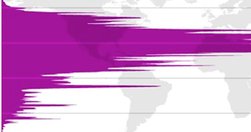
Did you know that almost 90% of the world’s population lives in the northern hemisphere?
opinionator.blogs.nytimes.com
Not many people, I suspect.
opinionator.blogs.nytimes.com
Excellent summary of the few facts known about the separatist movement.
bigthink.com
Scandinavia, obviously; but some surprising outposts elsewhere.
opinionator.blogs.nytimes.com
Nicosia, Jerusalem, Mitrovica...
en.wikipedia.org
The one part of Africa that no state claims as part of its territory.

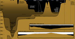
vis4.net
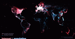
"shows more than 80,000 populated places in blue and about 350,000 locations of IP addresses in red. White dots indicate places where many people live and many IP addresses are available."
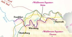
opinionator.blogs.nytimes.com
June 13th, 1990, was a historic day for weather forecasting in Germany. For the very first time, the weather map on the Tagesschau showed the newly reunited country’s international borders.
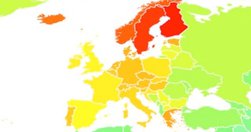
bigthink.com

Fascinating - Belgium and Switzerland invisible, Thailand way more prominent than its neighbours.
www.zerogeography.net

Interesting survey of knowledge production, though I would have some queries about the frame.
bigthink.com
Brooks, runs, branches, rios, etc - fascinating.
bigthink.com
Looking into alignments.
www.crispian.net
For the two of you who are interested and haven't seen this yet!
thewertzone.blogspot.com
Westeros v Europe (for George R.R. Martin fans)
urbantick.blogspot.com
density of twitter updates across New Yorkm London, Paris and Munich

